
Eau Claire - From SawMill to Skyline
This was the Eau Claire – from Sawmill to Skyline Jane’s Walk on May 2, 2026. Feel free to use it as a self-guided tour.
Jane’s Walk is a global festival that was started in Toronto in 2007 by friends of Jane Jacobs, to honour her legacy as a writer & activist who changed the way people think about cities. One of her greatest contributions was to highlight the role of ordinary citizens in the ongoing evolution of their cities.
Jane’s Walk is now a global phenomenon – with more than 200 cities around the world holding Jane’s Walks this weekend, from Istanbul, Turkey to Montevideo, Uruguay to Calgary, Alberta. We have 145 walks over these three days, and our festival is organized by the Federation of Calgary Communities, who do great work year-round assisting community associations and hosting events.
Before we begin, I’d like to acknowledge Robert Craig and William McLennon, who both grew up in the neighbourhood they used to call U Claire. William wrote a book called 711 Eau Claire Avenue, and Robert wrote an article for our Newsletter back in 2018, and all of the intimate, domestic details I’ll mention today come from those two sources. The Glenbow Archives and the Calgary Herald are the sources for most of the rest of the historical portion of this talk.
You are participating in this walk at your own risk. Please obey all traffic signs & regulations and keep yourself and each other safe. And please do not walk beyond your limits; you can leave the walk at any time. Just let us know. While we will be strolling and stopping throughout the neighbourhood, we will never be more than 10 minutes brisk walk from this location.
MEETING PLACE / STOP ONE – EAU CLAIRE AND BOW RIVER LUMBER COMPANY
Being this close to downtown, there has always been a push/pull between residential and commercial development in this neighbourhood, so it’s hardly a surprise that we owe our name to the first large commercial development and the workers who settled around it.
The Eau Claire and Bow River Lumber Company was chartered by the state of Wisconsin in 1883 to exploit the timber rights on 100 square miles (260 sq km) around the Bow, Kananaskis and Spray Rivers.

The first act of business was to dismantle a complete sawmill at Eau Claire, Wisconsin and ship it to Calgary, complete with a predominantly Norwegian crew of skilled workmen with experience developing new lands. Because the rail lines didn’t match, the workers spent a full week manually transferring the heavy machinery and all goods from the American tracks onto the CPR tracks at Winnipeg.
They arrived here on June 6, 1886 and worked long hours all summer and fall to build the mill and to install the machinery.
The mill was set up in Calgary, and two logging camps were established, one on the Kananaskis and one on the Bow at Silver City west of Banff. Timber was cut every winter, floated to Calgary in spring, and sawed into lumber in summer and fall. This was one of Calgary's major industries, which would soon turn out three carloads of lumber daily, not only for Calgary, but for the surrounding territory some 100 miles in every direction.
The Norwegians who came west at that time settled in newly built cottages on streets adjacent to the mill, forming the Eau Claire district.
The Operations Manager, Peter Prince, was an enterprising guy who created an island from a peninsula by digging out the land and allowing the logs to float right up to the sawmill. He also formed the Calgary Water Power Company in 1890, built a dam on the Bow River to harness hydroelectricity, and later became involved in other business ventures in Calgary, including a flour mill, a meat-packing plant, grain elevators and a brewery.
BE CAREFUL CROSSING THE BIKE PATH; LOOK BOTH WAYS AND GO WHEN SAFE
STOP TWO – RIVER OUTLOOK
This viewing platform is a new addition to the neighbourhood and strikes me as the place to stop and imagine the interactions this river has had with humans over millennia.
We acknowledge the traditional territories and oral practices of the Blackfoot (Siksika, Piikani, and Kainai), the Tsuut’ina (Sarcee), the Stoney Nakoda First Nations, the Métis Nation (Region 3), and all people who make their homes in the Treaty 7 region of Southern Alberta.
First Nations used the Bow River as a vital resource for travel, trading, and sustenance, with the confluence – about 2 km down this pathway -- where the Bow and Elbow Rivers meet serving as a neutral site for trade, ceremonies, and, in 1877, the signing of Treaty 7.
The river provided essential resources, with reeds used for bows (giving the river its name), relatively sheltered banks for winter camping, and hunting grounds for buffalo. It was also a natural corridor for movement across the prairies.
The Bow River remains deeply significant to the Treaty 7 Nations and the Métis Nation in the region, connecting their history, spirituality, and culture to this land.
STOP THREE – JAIPUR BRIDGE
Who can tell me why this is called the Jaipur Bridge?
The City of Calgary has six official sister city relationships focused on international cooperation, economic development, and cultural exchange.
Can anyone name our other five sister cities?
Daejeon, South Korea (since 1996)
Daqing, China (since 1981)
Jaipur, India (since 1973)
Naucalpan, Mexico (since 1994)
Phoenix, United States (since 1997)
Quebec City, Canada (since 1956)
These relationships are managed by the City of Calgary to foster mutual benefits in business, education, and culture. For example, the Daqing relationship focuses on energy, while Jaipur focuses on manufacturing.
STOP FOUR – PROMENADE SLIGHTLY WEST OF JAIPUR BRIDGE
We can’t walk along the Bow River without talking about flooding
• Calgary has a long history of major flooding, with significant events occurring in 1879, 1897, 1902, 1915, 1929, 1932, 2005, and most notably, 2013. The 2013 flood forced over 80,000 evacuations and caused widespread damage. Total economic loss has been estimated between $5 and $6 billion! There was one death in Calgary and four in High River.
• The silver lining of this terrible event was the way everyone stepped in to help. The city asked for 500 volunteers to show up at McMahon Stadium, and thousands showed up. The city just said, “We can’t manage this many people, spread out into the neighbourhoods and help anyone you can.”
• People went into homes to pull out water-damaged belongings, flooring and drywall. Volunteers hauled loads to the dump while other volunteers delivered water, coffee and sandwiches. Calgary’s annual Neighbours’ Day was created to honour that proof of the best of humanity.
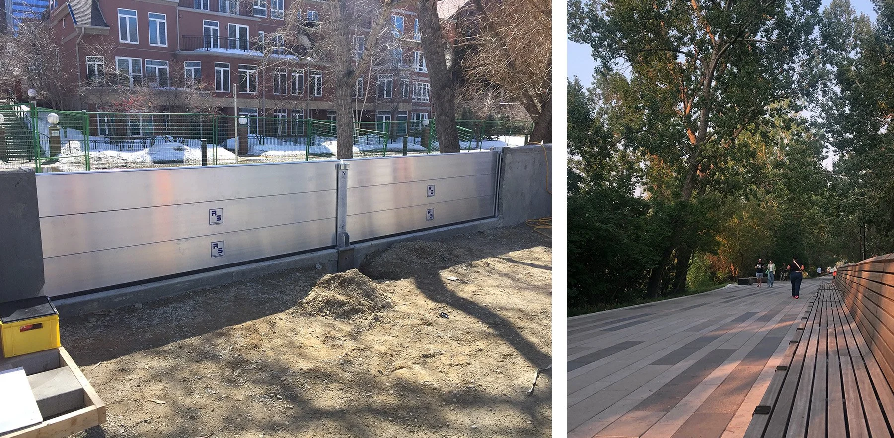
• Since then, the city & provincial governments have invested hundreds of millions of dollars in flood mitigation projects, including raising the riverbank by as much as 1.5 meters along this corridor. The beautiful promenade we’re standing on is part of that.
o The seating clads concrete walls designed to hold back the river in case of a 1:200 year flood.
o Hidden underneath the seats are metal panels, which will be quickly installed across all of the gaps in the walls if flooding is imminent.
We’ve heard about the best of humanity, and we’re witnessing how beautiful flood mitigation can be – now let’s imagine dystopia for a minute: in the 1940s, the CPR proposed running railway tracks along the south bank of the Bow River.
Can you imagine smelly, noisy, dangerous train tracks separating downtown from the river?
Fortunately, a man named Jack Leslie led the fight against the plan and won the two-year battle. Serving on the Land Committee, he also persuaded the City to purchase Bow riverbank property as it became available.
In 1947, the City of Calgary purchased the land from the Prince family and created a park. Today, Prince’s Island is one of the premier urban parks in North America.
In 1965, Jack became the first native-born mayor of Calgary. 1966 One of his first projects was building a walking trail linking the Calgary Zoo with Shouldice Park - the beginning of Calgary's extensive parkway path system. Today, Calgary has the most extensive urban pathway and bikeway network in North America. The City of Calgary maintains approximately 580 km of regional pathways, 220 km of local pathways and 95 km of trails. Enough to stretch to Saskatoon.
Jack Leslie was an influential environmentalist, and he worked to maintain the beauty of the Bow River’s edge and began the process of making Prince’s Island Park the jewel it is now. The City of Calgary created the Jack Leslie Youth Environmental Grant in 2004, which supports youth-led projects that protect and improve Calgary’s natural environment.
Walk down the Promenade and turn left past 500 Eau Claire Estates.
BE CAREFUL CROSSING THE BIKE PATH; LOOK BOTH WAYS AND GO WHEN SAFE; PEDESTRIANS HAVE A YIELD SIGN
STOP FIVE – 5TH STREET AND EAU CLAIRE AVENUE
In the 1940’s and 50’s this was the site of the Buffalo Stadium. Wartime baseball games would attract 3,000 to 4,000 spectators. These photos are from the Glenbow Archives – look at how formally they are dressed! Another cool thing we can see in the background are the homes in what was then a normal family neighbourhood.
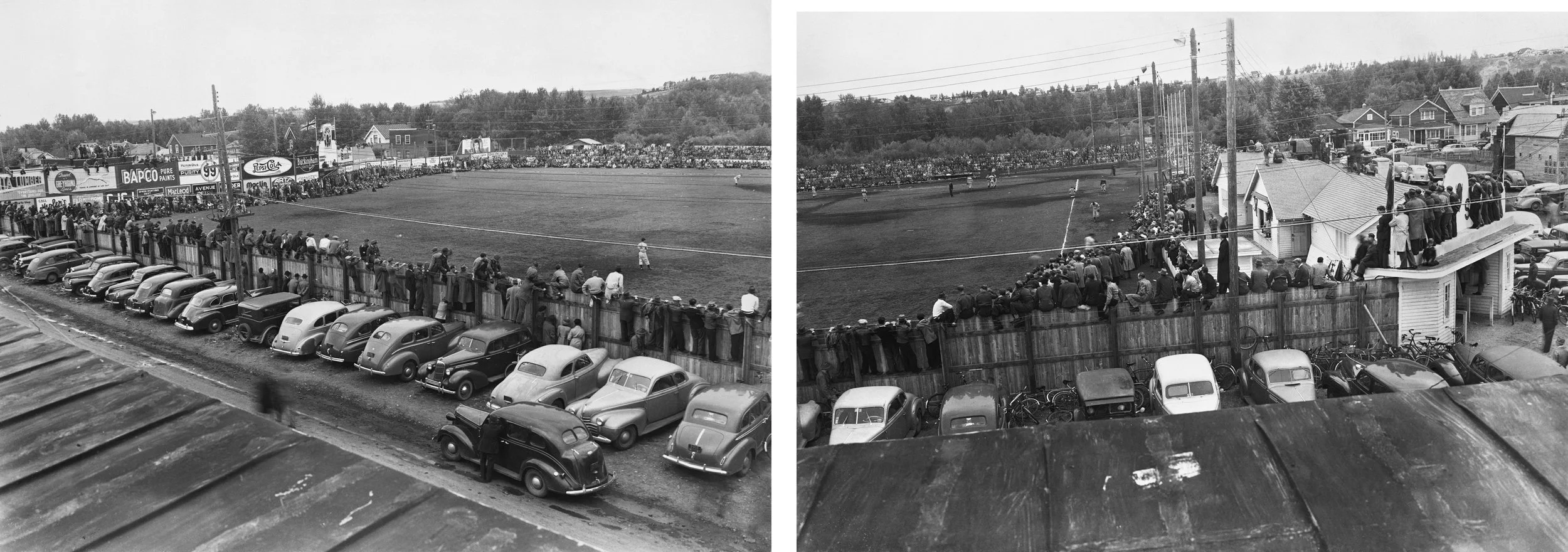
In the winter there were three ice rinks over this same area and William McLennan said, "Hockey kept me out of reform school and helped me get my education." He went to Michigan State University on a hockey scholarship. The Buffalo Athletic Association Hockey League was also the first home for at least three future NHLers
Frank McCool (goalie for the Leafs),
Hank Bassen (goalie for the Blackhawks) and
Ron Stewart (Right-winger who won the Cup 3 times with Toronto from 1962 to ’64)
Of all the amazing things I learned researching this tour, the fact that the Leafs were a dynasty team in the 60’s was the biggest surprise!
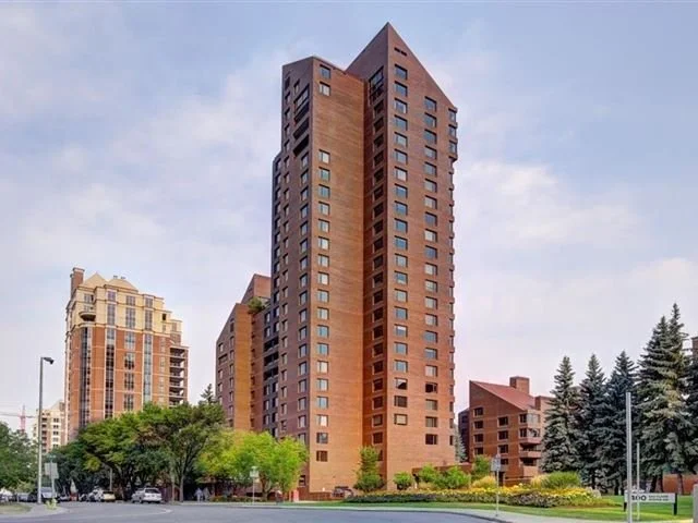
Jump forward in time and in the late ‘70’s driving into downtown over the Louise Bridge this was a desolate land of gas stations, parking lots and squat low-rise office buildings without personality or style. Then Eau Claire Estates arrived in 1981. It was designed by Chicago-based Skidmore Owings & Merrill architects, renowned high-rise specialists since 1936. Today, SOM is best known as the architect of one of world’s tallest building - Burj Khalifa tower in Dubai.
Eau Claire Estates has hints of modernism with the various slanted rooftops that anticipate the roofs of future office buildings like First Canadian Place and Suncor Centre. It was one of city’s first luxury urban condos. Though it was supposed to be the start of a mega Eau Claire urban renewal project, it sat all alone for nearly a decade.
It wasn’t until the mid ‘90s that Eau Claire’s revitalization was rebooted with the opening of Eau Claire Market, Eau Claire YMCA, Sheraton Eau Claire Hotel and Prince’s Island Estates condos. But it took another 10 years to get projects like the Princeton Grand and The Princeton Hall condos off the ground.
STOP SIX - Joe Phillips Building - The Commercial and Industrial District
In the first half of the last century, the neighbourhood was truly mixed with many businesses and factories as well as workers' homes, some of which were far from humble – Prince’s House & Thorpe House now stand in Heritage Park and are quite grand.
This is the last commercial building from that era that remains. It demonstrates the importance of Calgary-based business to the development of agriculture in Western Canada. The structure was completed in 1911 and owned by a group of businessmen.
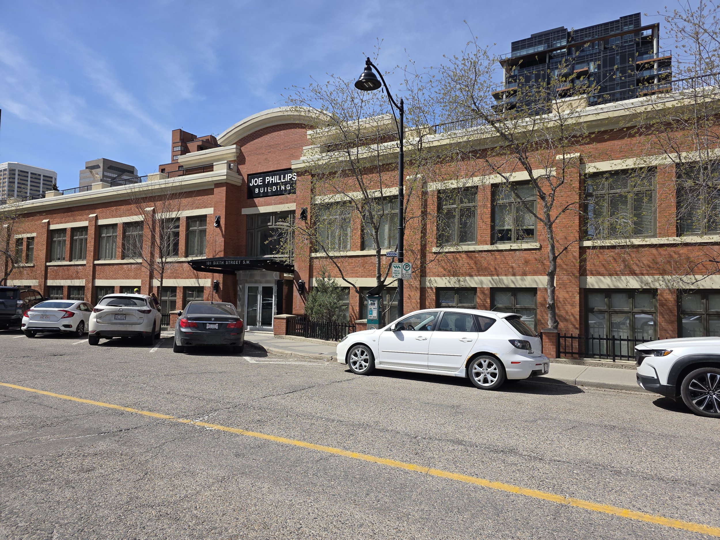
The early uses of this building included offices for the many enterprises of the partners, which ranged from farming and real estate development to printing and publishing, including the popular Western Agriculture newspaper. Publishing was so important that by 1917, the name of the building was changed to The Graphic Arts Building. In about 1965, it was purchased by Joe Phillips, who was the founder of the PBA Group of companies, which are still developing real estate in Calgary today. They are the firm behind the Element by Westin, The Dorian and The Courtyard, all three of which are easy walking distance from here.